Manor Road, around Este
Come closer: explore twelve restaurant and food destinations around Este and Suerte. Select a place and choose Peek inside, or zoom into a painted roof. Patios and courtyards have their own close views. Room arrangements are illustrated interpretations from photographs. Este Garden stays connected to its own living map.
Connecting to Este Garden…
Zoom in to explore the illustrated streets and paths around Este Garden.
Places, and the people behind them.
Start with the restaurants around our first two painted neighborhoods. Follow a place, peek into a dining room, or make your own Austin persona.
Map a restaurant.
Explore the Suerte front-room study, connect photos to features, and add your own rooms and measurements.
No places match these filters. Try another name or clear the filters.
Meet the community.
Members choose their names, profile links, appearance, and map actions. These are playful map characters; venue connections are self-described.
Open this view to load community personas.
The Austin work grid
Production grid over Austin and surrounding context. The rectangle is not a city-limit boundary. Tap a block or choose its name. Density reflects saved destinations and illustration priority, not a population survey. The grid is hidden in the illustrated map.
The reference stays. The painted city grows.
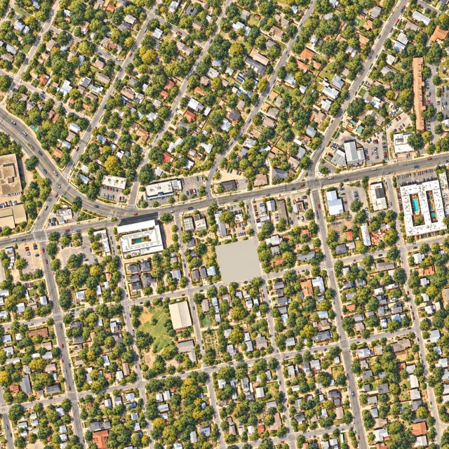
Panem supplies the visual language: small dimensional buildings, coherent painted ground, generous trees and a warm miniature world. Austin supplies the geography. Streets, land and landmarks are checked against reference data before each illustration pass.

A repeatable section job
- Read the section record, exclusions and approved neighboring artwork.
- Collect street, building and landmark references. Record their dates and uncertainty.
- Paint one complete scene with overlap around every edge.
- Inspect the result, record its native size, and measure visible anchors.
- Check adjoining roads, roof scale, tree density, light and all protected areas.
- Save the master, prompt, guide, registration and next step. Advance only after coverage and joins are checked.
Every section has an immutable ID, a production name, its geographic frame, neighboring IDs, work status and a job record. Generic sector names are working names, not official Austin neighborhoods. The current painted scenes cover parts of Manor Road around Este and East 6th and 7th Streets around Suerte. Unfinished sections remain on the work grid; completed detail panels do not mark a whole section complete.
What is already here
MapWoven already has an Austin reference map with building footprints, roads, terrain and places, alongside the Panem atlas. The painted atlas now includes Manor Road and the blocks around Suerte on East 6th Street. The separate Este Garden map supplies the current garden artwork and full interactive view; Austin does not maintain a second garden.
The Manor core is approximately 622 metres across at Este. The Suerte core is approximately 415 metres across. The 125 × 200 base grid preserves every existing painting in place. Quiet areas share one landscape across up to 100 blocks; busy blocks can add individual paintings, and restaurants or special places can add 100 finer areas inside a registered frame. The 1,000- and 10,000-block registers remain archived. No whole section is marked complete yet. Restaurant exteriors use matching neighborhood frames; the illustrated interiors reveal only within measured roof openings. Room arrangements are interpretations from photographs, not surveyed floor plans.
Restaurant interiors
Open the restaurant measurement studio · Compare all twelve map footprints, inspect features and check distances and angles.
Twelve destinations now offer close views: Este, Suerte, Mi Madre’s, School House Pub, Dai Due, Bird Bird Biscuit, Canje, Lazarus, Salty Sow, El Chile, Patrizi’s and Bar Toti. All twelve reveal directly within their existing mapped footprints, including Bar Toti’s square building beside Este, Salty Sow’s dining room, El Chile’s patio and Patrizi’s courtyard. Furniture and room proportions remain interpreted; older photographs may differ from the current setting.
Este’s pale oak, blue seating and covered deck are drawn from its official dining-room photographs. Suerte’s wood shelving, white chairs, textiles and covered deck are drawn from its official dining-space photographs. These paintings add no recommendation or subscription status.
Reference register
- Este official address and location — 2113 Manor Road; embedded map coordinates used for the starting anchor.
- City of Austin street map and street geometry — 90 intersecting street features captured for the core reference window.
- City of Austin Building Footprints 2021 layer — 669 intersecting reference features; records may derive from earlier imagery.
- Esri World Imagery — aerial reference. Capture date has not been verified.
- Suerte official address — 1800 East 6th Street; coordinates from the existing OpenStreetMap venue record.
- Saved MapWoven release review, September 11, 2026 — read-only Panem style reference.
Sources retrieved September 12, 2026. Aerial imagery © Esri and its imagery contributors. City street reference: City of Austin. This working atlas makes no claim of official mapping status.